
Regional Atlas – Infrastructure for Spatial Information in the European Community (INSPIRE)
The purpose of the Directive 2007/2/EC of the European Parliament and of the European Council establishing an Infrastructure for Spatial Information in the European Community (INSPIRE) is to ensure spatial information for the formulation and implementation of Community policies. It is primarily meant to ensure the accessibility and usability of data closely related to the state of environment.
The directive aims at the harmonisation, combination and standardisation of the spatial data infrastructure of Member States. It regulates the issues of metadata, the standardisation and interoperability of spatial data sets and services, network services and the sharing of data at EU and Member State levels. It is important that Member States create their own national solutions according to the specifications of INSPIRE.
The HCSO is responsible for the Statistical units, Population distribution — demography spatial data themes. Besides, HCSO publishes data in Agricultural and aquaculture facilities spatial data theme.
Official web page of INSPIRE: https://inspire.ec.europa.eu/
Statistical units
Units for dissemination or use of statistical information.
1 square kilometre grid
The area of Hungary is covered by a 1 km² grid. The projection system of the grid is EOV.
- Download map (ZIP, 5,704 kB)
- Download metadata (XLSX, 13 kB)
25 square kilometre grid
The area of Hungary is covered by a 25 km² grid. The projection system of the grid is EOV.
- Download map (ZIP, 1,391 kB)
- Download metadata (XLSX, 13 kB)
Territorial registration identification code system
The territorial registration identification code system is a register system of the name of administrative territorial units and of the code of their existence, territorial classification and other characteristics. It is a geographical classification system, consisting of two main parts. The first part is made up of a settlement identification number (positions 1–5) and the second of a series of grouping criteria (positions 6–50). Through a part of it, the settlement identification number, it ensures the computerised processing and sorting of statistical data and information available on settlements.
More details on the territorial registration identification code system page »
Population distribution – demography
Geographical distribution of people, including population characteristics and activity levels, aggregated by grid, region, administrative unit or other analytical unit.
Data on population and dwelling numbers, coming from the 2022 census, can be classified to this spatial data theme. The data were depicted on grid maps. On these the area of Hungary is divided by a 1 km² grid and not by administrative borders, and the colour of the grid cells is growing darker with the increase in the absolute number of the data they contain. This is made possible by the identification of addresses by EOV co-ordinates.

The map shows the resident population per 1 km². The darker the cell is, the more people it contains. The curiosity of the map is that you can see the well-known figure of Hungary based on only population distribution without any hydrography and road network: the big lakes and rivers can be recognised, and the densely populated inner areas of cities and the sparsely located, thinly populated detached farms on areas of the Great Plain can also be seen.

The map shows the dwelling stock per 1 km². The dwelling stock comprises occupied dwellings, unoccupied dwellings (used seasonally, as a secondary home, for other purpose than living or being vacant) and occupied holiday homes. The darker the cell is, the more dwellings it contains. The curiosity of the map is that you can see the well-known figure of Hungary based on only the distribution of the dwelling stock without any hydrography and road network: the big lakes and rivers can be recognised, and the densely populated inner areas of cities and the sparsely located, thinly populated detached farms on areas of the Great Plain can also be seen.
Maps and data for 2011
- Resident population per 1 km², 2011 (JPEG)
- Resident population per 1 km², 2011 (PDF)
- Resident population per 1 km², 2011 – adatok (XLSX)
- Dwelling stock per 1 km², 2011 (JPEG)
- Dwelling stock per 1 km², 2011 (PDF)
- Dwelling stock per 1 km², 2011 – adatok (XLSX)
Agricultural and aquaculture facilities
Description of spatial data theme: farming equipment and production facilities (including irrigation systems, greenhouses and stables).
Data on the number of holdings and on agricultural labour force, coming from the 2010 agricultural census, can be classified to this spatial data theme. The data were depicted on grid maps. On these the area of Hungary is divided by a 25 km² grid and not by administrative borders, and the colour of the grid cells is growing darker with the increase in the absolute number of the data they contain. This is made possible by the identification of holdings according to their headquarters by EOV co-ordinates.
Number of holdings per 25 km² (holding density), 2010
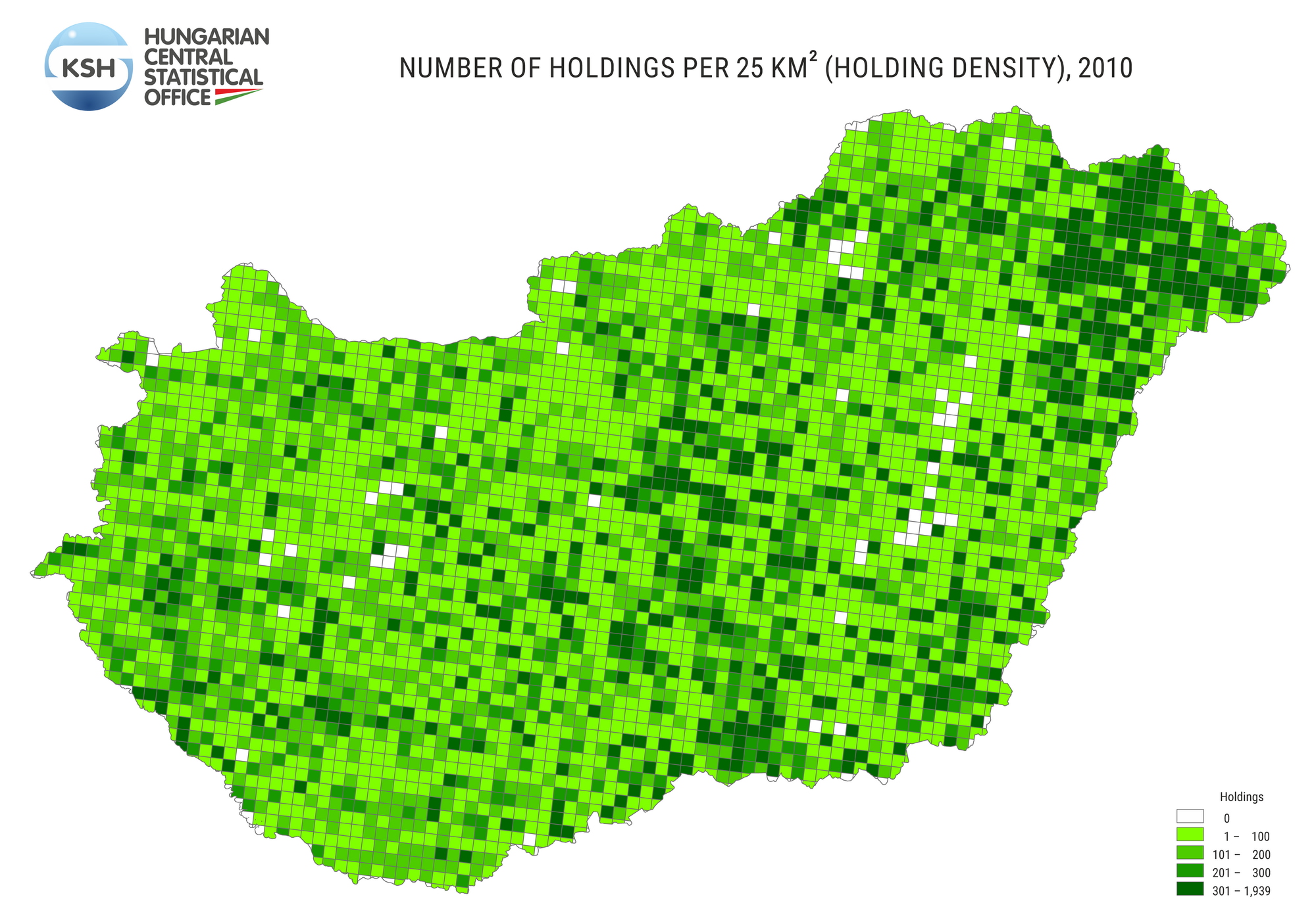
download printable version (PDF, 419 kB) download data (XLSX, 117 kB)
The area of Hungary is covered by a 25 km² grid, and the colour of the grid cells is directly proportional to the number of the holdings they contain. In 2010, 577 thousand holdings were registered in the agricultural census, nearly 568 thousand of which were private holdings and somewhat more than 9 thousand were agricultural enterprises. Therefore, the spatial distribution of holdings is basically determined by the location of private holdings. The value is high in the axis between the agglomeration of Budapest and Szeged, and in Szabolcs-Szatmár-Bereg County. In these areas a high proportion of vegetable and fruit production is typical.
Annual work units per 25 km², 2010
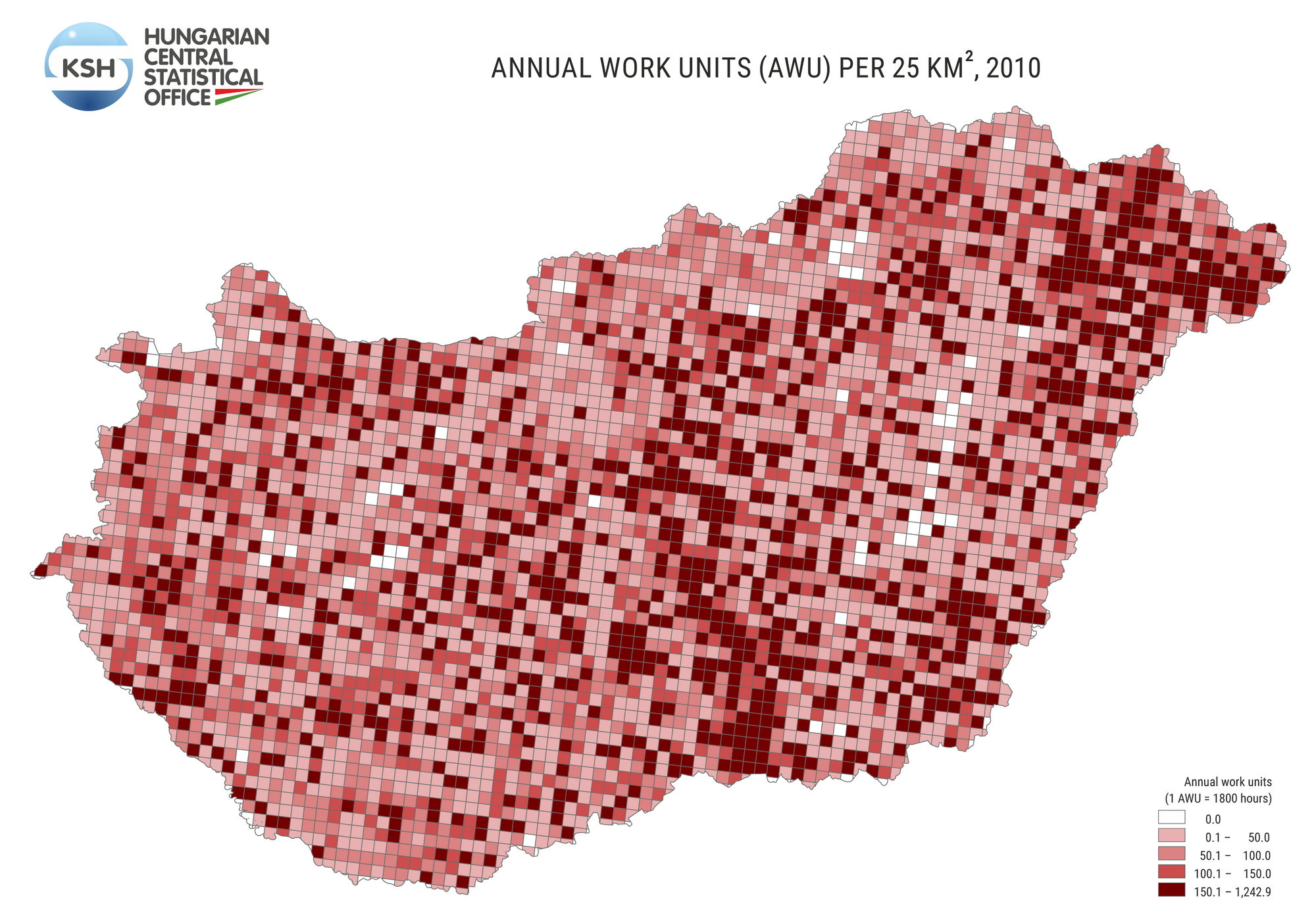
download printable version (PDF, 416 kB) download data (XLSX, 129 kB)
The area of Hungary is covered by a 25 km² grid, and the colour of the grid cells is directly proportional to agricultural labour input, expressed in annual work units (1 AWU=1,800 hours), in the holdings they contain. In 2010, according to data of the agricultural census, the agricultural activities of non-salaried labour force and permanent employees took the time of 403 thousand people working full-time through the whole year (the map does not show seasonal labour force). Labour density shows a similar picture to that of holding density. Labour input is relatively high in labour intensive sectors, such as vegetable and fruit production, therefore, darker spots can be seen on the central and northeastern areas of the Great Plain.
Further maps and data
 Further 1 and 25 km² graticule thematic maps to be found within the Interactive Mapping Application (TIMEA) topics:
- Census
- Agriculture – Farm structure survey, 2010
- Agriculture – Orchard survey, 2017
- Agriculture – Agricultural Census, 2020
- Agriculture – Vineyards of vine regions, 2020
Data on the selected indices may be downloaded in CSV format by opening the so-called attribute table.