
INSPIRE – Population distribution – demography
Description of spatial data theme
Geographical distribution of people, including population characteristics and activity levels, aggregated by grid, region, administrative unit or other analytical unit.
Spatial data
Data on population and dwelling numbers, coming from the 2011 census, can be classified to this spatial data theme. The data were depicted on grid maps. On these the area of Hungary is divided by a 1 km² grid and not by administrative borders, and the colour of the grid cells is growing darker with the increase in the absolute number of the data they contain. This is made possible by the identification of addresses by EOV co-ordinates.
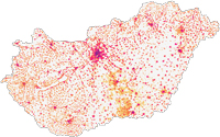 Resident population per 1 km²
The map shows the resident population per 1 km². The darker the cell is, the more people it contains. The curiosity of the map is that you can see the well-known figure of Hungary based on only population distribution without any hydrography and road network: the big lakes and rivers can be recognised, and the densely populated inner areas of cities and the sparsely located, thinly populated detached farms on areas of the Great Plain can also be seen.
Download map » (pdf, 2 798 KB) Download data » (xlsx, 1 525 KB)
Download metadata » (xls, 38 KB)
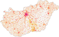 Dwelling stock per 1 km²
The map shows the dwelling stock per 1 km². The dwelling stock comprises occupied dwellings, unoccupied dwellings (used seasonally, as a secondary home, for other purpose than living or being vacant) and occupied holiday homes. The darker the cell is, the more dwellings it contains. The curiosity of the map is that you can see the well-known figure of Hungary based on only the distribution of the dwelling stock without any hydrography and road network: the big lakes and rivers can be recognised, and the densely populated inner areas of cities and the sparsely located, thinly populated detached farms on areas of the Great Plain can also be seen.
Download map » (pdf, 2 809 KB) Download data » (xlsx, 1 519 KB)
Download metadata » (xls, 38 KB)