
Infrastructure for Spatial Information in the European Community (INSPIRE)
The purpose of the directive of the European Parliament and of the European Council (2007/2/EC) establishing an Infrastructure for Spatial Information in the European Community (INSPIRE) is to ensure spatial information for the formulation and implementation of Community policies. It is primarily meant to ensure the accessibility and usability of data closely related to the state of environment.
The directive aims at the harmonisation, combination and standardisation of the spatial data infrastructure of Member States. It regulates the issues of metadata, the standardisation and interoperability of spatial data sets and services, network services and the sharing of data at EU and Member State levels. It is important that Member States create their own national solutions according to the specifications of INSPIRE.
Available spatial data at present:
- Statistical units: 1-kilometre and 5-kilometre grids
- Population distribution — demography: population and dwelling numbers from population census held in 2011
- Agricultural and aquaculture facilities: number of agricultural holdings and agricultural labour force data from agricultural census held in 2010
Metadata descriptions are available for these data here.
Number of holdings per grid, 2010
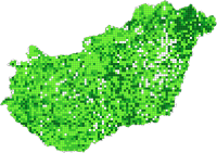 The area of Hungary is covered by a 25 km² grid, the colour of the cells (grids) is proportional to the number of the holdings. The geographical position was determined by the ETRS 89 (European Terrestrial Reference System 89) co-ordinates of the holdings. In 2010 577 thousand holdings were registered through the Farm structure survey, out of which 568 thousand is the number of private holdings), and the other part is agricultural enterprises (more than 9 thousand). The spatial distribution of the holdings is basically determined by the location of the private holdings. The value is high in the axis between the agglomeration of Budapest and Szeged, and in Szabolcs-Szatmár-Bereg county. In these areas the high proportion of vegetable and fruit cultivation is the typical.
Download map »
Annual working unit in the agriculture per grid, 2010
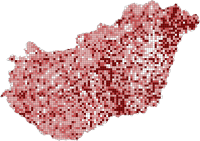 The area of Hungary is covered by a 25 km² grid, the colour of the cells (grids) is proportional to the agricultural labour expenditure. The geographical position was determined by the ETRS 89 (European Terrestrial Reference System 89) coordinates of the holdings. In 2010 according to the data of the Farm structure survey, agricultural activities take the time of 442 thousand people working through the whole year in full time. The labour density shows very similar picture to the holding density. The labour expenditure is higher in the labour intensive sectors, such as vegetable and fruit cultivation. Darker spots are outlined on the Central- and Northeast part of the Great Plain.
Download map »
Official web page of INSPIRE: http://inspire.jrc.ec.europa.eu/