
Regional Atlas – Other territorial delimitations
The majority of the other territorial delimitations is adjusted to administrative boundaries. Their range is wider than the listed ones, the territorial code system as well as certain special fields (e.g. nature conservation, water conservancy) contain them.
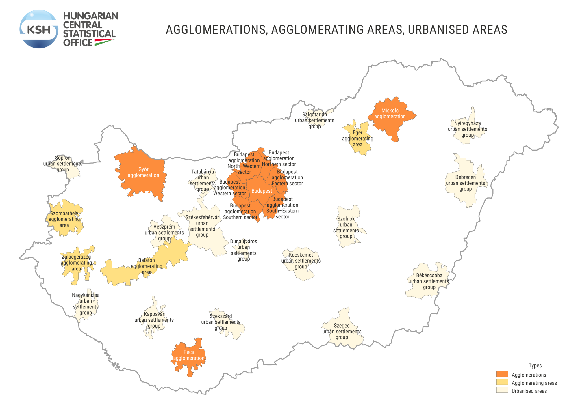
Agglomerations, agglomerating areas, urbanised areas
The Hungarian Central Statistical Office considered the revision of the delimitations of agglomerations, agglomerating areas, urbanised areas – which play a decisive role in the settlement system – important, utilising the data of the 2011 census. The delimiting, performed in 2014, basically resembles the 2003 work from methodological point of view, in order to make results easily comparable. Out of the twenty three regions delimited in 2014 two were not defined based on the survey. The territory of the capital’s agglomeration is set by Act LXIV of 2005 on regional planning of the Budapest agglomeration, which left the delimitation determined by the – now revoked – Government Decree 89/1997 (V. 28.) unchanged. The Balaton agglomerating area stands for the settlements at- and close to the shore, listed in the Balaton-Act (Act CXII of 2000).
| Names of urbanised areas | Settlements included | |
|---|---|---|
| their number | towns | |
| Budapest agglomeration | 80 | 37 |
| Győr agglomeration | 68 | 4 |
| Miskolc agglomeration | 36 | 9 |
| Pécs agglomeration | 41 | 2 |
| Balaton agglomerating area | 53 | 13 |
| Eger agglomerating area | 17 | 1 |
| Szombathely agglomerating area | 52 | 2 |
| Zalaegerszeg agglomerating area | 51 | 1 |
| Békéscsaba urbanised area | 9 | 5 |
| Debrecen urbanised area | 13 | 5 |
| Kaposvár nagyvárosi településegyüttes | 23 | 1 |
| Kecskemét urbanised area | 8 | 2 |
| Nagykanizsa településegyüttes | 10 | 3 |
| Salgótarján urbanised area | 10 | 1 |
| Sopron urbanised area | 12 | 1 |
| Szeged urbanised area | 15 | 2 |
| Szekszárd urbanised area | 10 | 1 |
| Székesfehérvár urbanised area | 35 | 3 |
| Szolnok urbanised area | 12 | 3 |
| Tatabánya urbanised area | 11 | 1 |
| Veszprém urbanised area | 18 | 2 |
| Dunaújváros urbanised area | 5 | 2 |
| Nagykanizsa településegyüttes | 24 | 1 |
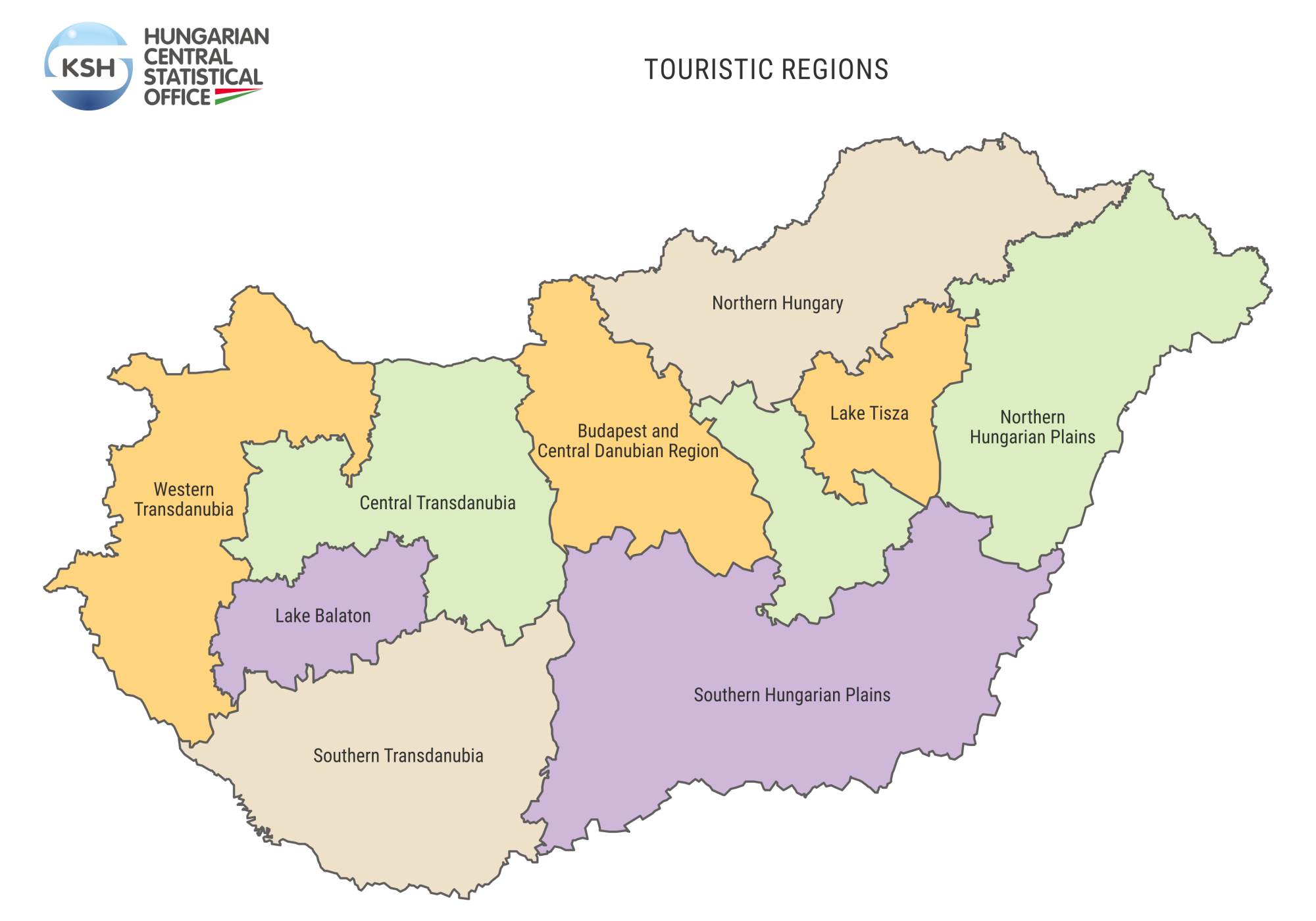
Touristic region
Decree 28/1998 (V. 13.) of the Ministry of Industry, Trade and Tourism ruled that tourism related regional, territorial tasks shall be addressed within the touristic regions framework. The Decree established nine touristic regions, these covering the whole country, being contiguous territorial units, except the Northern Great Plain. At their delimiting, the planning and statistical regions have been altered so they would comply with the delimitations of the special recreation areas. Their jurisdiction is to be found in the annex of the Act.
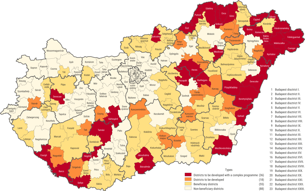
Beneficiary districts
Based on Government Decree 290/2014 (XI. 26.) on classification of beneficiary districts a system of 24 indicators assisted in deciding which are the beneficiary ones by right of their development level. The indicator-values were generated by aggregating settlem ent data. The beneficiary districts are the ones whose calculated complex indicator is below the complex indicator average of all districts. The prevailing Government Decree qualified 109 districts as beneficiary, based on this threshold indicator, out of which 18 districts qualified as ‘developable’, 36 districts as ‘developable by a complex programme’.
Beneficiary districts based on Government Decree 290/2014 (XI.26.)
Beneficiary settlements
Based on article 9 of Act XXI of 1996 on Regional development and Regional Planning the minister responsible for settlement development proposed a system of provisions for classifying beneficiary settlements and recommended their classification with the assistance of the minister responsible for the strategic planning of regional development. The Minister of the Prime Minister's Office prepared the legislation pertaining to beneficiary settlements. The Hungarian Central Statistical Office (by computing background calculations) and the specialists of the ministries concerned participated in elaborating the conditionalities, the Prime Minister’s Office proposed the threshold indicators. Indicators evaluating development/underdevelopment are basically identical for districts and settlements, the calculation method is following identical principles also. Government Decree 105/2015 (IV.23.) contains the classification of beneficiary settlements and the classification criteria.
Beneficiary settlements based on Government Decree 105/2015 (IV.23.)

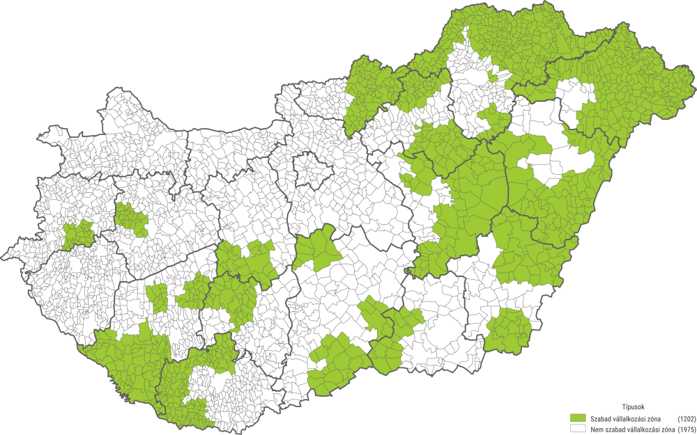
Free enterprise zones
Government Decree 27/2013 (II.12.) regulates the directives on creating and operating free enterprise zones. According to it the government declared settlements located in developable or developable by a complex programme districts based on Government Decree 290/2014 (XI.26.), or in any other underprivileged district from regional- economic development and employment policy point of view as free enterprise zones up until 31 December 2027. Enterprises functioning or moving into free enterprise zones may claim subsidies through tenders.
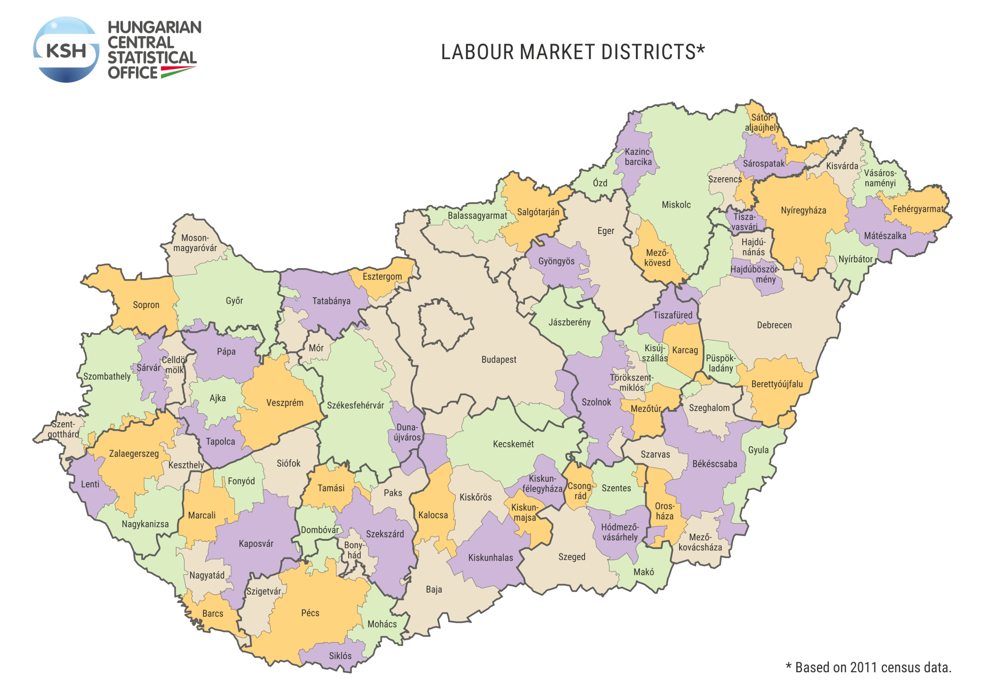
Labour market districts
The Hungarian Central Statistical Office in collaboration with the researchers of the University of Debrecen delimited labour market districts in 2017 by utilising domestic commuting data of the 2011 census. It is typical to the area units utilised mainly for employment policy purposes that the dwelling- and workplace of its inhabitants and workers is within the given unit, the proportion of commuters into and out of the district is small. The delimitation contains 84 contiguous districts which gained their names after the settlement showing the largest number of employees.
Attainable statistical information about constituencies
Act CCIII of 2011 on the Elections of Members of Parliament divides Hungary into 106 parliamentary single-member constituencies. The Census site of the Hungarian Central Statistical Office contains the most relevant data regarding parliamentary single-member constituencies. Census site data are available as per the following topics: number and characteristics of the population, households, families, dwelling stock data.